Flood Risk Survey
Enquire Today For A Free No Obligation Quote
At Flood Risk Survey, we provide comprehensive and fully compliant flood risk reports for properties and development sites across the UK.
Whether you are applying for planning permission, purchasing land, or protecting an existing building, our surveys assess the level of flood risk and provide tailored mitigation recommendations.
We combine strong local expertise with national guidance to ensure your report meets the requirements of planning authorities, the Environment Agency, and potential investors.
When Is a Flood Risk Survey Required?
A flood risk survey is often a legal requirement for developments located in or near designated flood zones or in areas with limited drainage capacity.
The survey provides planning authorities with clear evidence of how a proposed development will address potential flooding issues without causing harm to surrounding land or properties, ensuring safety and compliance.
What Types of Developments Need a Flood Risk Survey Report?
We prepare flood risk survey reports for many development types where planning regulations make them necessary, including:
- Developments within Flood Zones 2 or 3 – Areas with a higher probability of river or coastal flooding.
- Sites larger than one hectare – Regardless of flood zone classification.
- Projects close to rivers, reservoirs, or coastal areas – Where proximity to water sources increases flood potential.
- Locations with a history of surface water flooding – Even if located outside designated flood zones.
- Applications where the local authority requires a flood survey – As part of the planning approval process.
How Much Does a Flood Risk Survey Cost?
The cost of a flood risk survey ranges from £400 to over £1,200, depending on site size, flood zone classification, and the complexity of the work required.
Key cost factors include the need for hydraulic modelling, access to historic flood data, site-specific drainage reviews, and any additional inspections or mitigation advice.
Contact Flood Risk Survey to request a tailored quotation for your site.
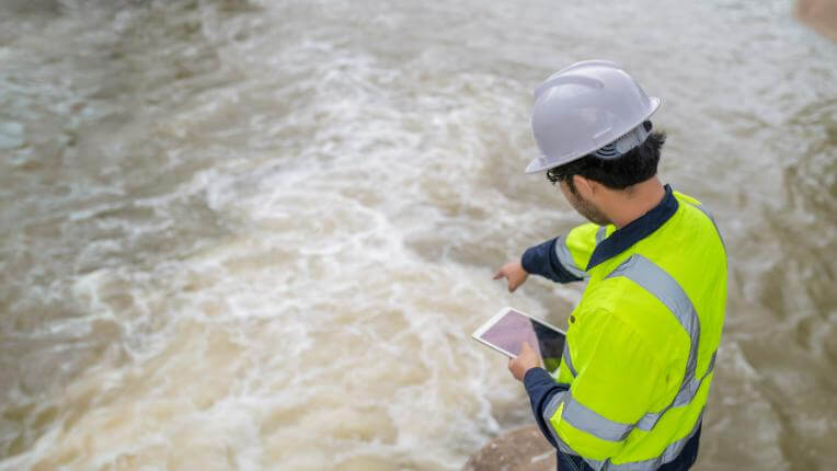
How Do Flood Risk Surveyors Assess Flood Hazards?
Our flood risk surveyors use Environment Agency data, local authority records, and on-site inspections to deliver precise assessments.
We examine land elevations, drainage infrastructure, and water flow behaviour to understand how a site might be affected during extreme weather. When necessary, advanced hydraulic modelling is used to simulate realistic flooding scenarios and highlight any vulnerabilities.
Why Are Flood Risk Surveys Important for Planning Applications?
A flood risk survey report is a required submission for planning applications, especially for developments in designated flood zones or areas with drainage constraints.
A professionally prepared report can strengthen your application by demonstrating responsible and proactive flood risk management.
Can a Flood Risk Survey Include Flood Prevention Solutions?
Our flood risk surveys do more than identify potential flood hazards—they also recommend practical, site-specific solutions, which include raising finished floor levels, adding flood barriers, upgrading drainage systems, or integrating sustainable drainage systems (SuDS).
These measures help meet planning requirements and protect the site for years to come.
How Long Does It Take to Complete a Flood Risk Survey?
For most residential developments, a flood risk survey can be completed within one to two weeks.
Larger or more complex sites, particularly those requiring detailed hydraulic modelling, may take longer. We work to agreed timelines to help keep your planning process on schedule.
What Does a Flood Risk Survey Report Contain?
A standard flood risk survey for a property or development includes:
- Flood zone mapping – Showing the site’s position within Environment Agency flood risk categories.
- Historic flood records – Reviewing previous flood incidents and their effects on the area.
- Topographical analysis – Assessing gradients and land levels to understand water movement.
- Identification of flood sources – Including rivers, tidal waters, groundwater, and surface water run-off.
- Flood modelling – Simulating flood depths and flow velocities for different return periods.
- Drainage capacity review – Analysing existing systems and their performance under stress.
- Mitigation recommendations – Suggesting measures to minimise residual flood risk.
Do Flood Risk Survey Reports Meet Legal and Planning Standards?
All our flood risk survey reports are produced in accordance with Environment Agency standing advice, Planning Policy Statement (PPS25) guidance, and local authority planning requirements. This ensures they meet all technical and compliance standards for acceptance by the relevant authorities.
Contact Flood Risk Survey today to arrange an assessment for your property or development.
Find More Info
Make sure you contact us today for a number of great flood risk survey services.
For more information on flood risk survey, fill in the contact form below to receive a free quote today.
★★★★★
“Flood Risk Survey’s report was comprehensive and easy to understand, which really helped when submitting our planning application in Devon. Their thorough site assessment and practical mitigation advice made a complex process much simpler. I wouldn’t hesitate to recommend their services.”
Celeste Harrington
Greater London
★★★★★
“We were impressed by Flood Risk Survey’s attention to detail and local expertise when assessing flood risks for our coastal property in Cornwall. Their clear communication and tailored recommendations gave us confidence in how to protect our investment long term.”
Alistair Pembroke
Greater London